 Spacebriefer
Milliseconds Matter: Why Satellite Delay Shapes Drone Warfare
When a drone operator sits hundreds of kilometres away from the aircraft, control depends on how quickly data travel between the ground and the sky. If the connection is delayed by half a second, the operator is not seeing the present: they are seeing the immediate past. Their steering command reaches the drone late as well.
That difference may sound small. In everyday internet use, it usually is. In drone warfare, it can determine whether an operator can follow a moving vehicle, avoid a threat, or strike a target accurately. This is why satellite altitude has become strategically important, especially the shift from traditional satellites in high orbits to large constellations in low Earth orbit.
What latency means in war
Latency is the delay between sending information and receiving it. In military operations, it affects how quickly forces can observe a situation, understand it, make a decision and act.
A remotely piloted drone depends on a constant exchange of data. Video from its camera travels to the operator; commands from the operator travel back to the drone (Dougherty, 2002). Status information such as position, altitude, speed, fuel or battery level also moves through the network. If this exchange is slow, the operator is effectively flying the aircraft using an outdated picture of the battlefield.
The problem becomes most visible when a drone operates beyond the range of ordinary radio links. A small drone close to its controller may use a direct radio connection with very little delay. But a drone with a longer range, operating far from friendly forces, often needs a satellite link. In that case, the physics of satellite orbits becomes a military issue.
Why satellite height matters
Satellites orbit Earth at very different heights. Two categories matter most for military communications.
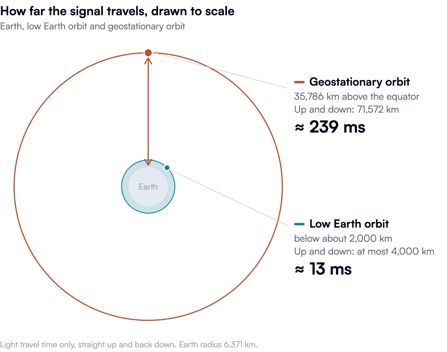
Geostationary satellites, or GEO satellites, orbit about 35,786 kilometres above the equator. At this altitude, they circle Earth at the same rate at which the planet rotates. From the ground, they therefore appear to stay above roughly the same point (Riebeek, 2009).
This makes GEO satellites useful for wide, continuous coverage. One satellite can serve a very large region, and ground antennas can point at a fixed position in the sky. For decades, this has made GEO attractive for television, telecommunications and military communications.
The disadvantage is distance. A signal must travel from Earth to the satellite and back again. Even at the speed of light, that takes time.
A simplified calculation shows the scale of the problem. The distance from a ground terminal to a GEO satellite and back is roughly 71,572 kilometres. Light travels at about 299,792 kilometres per second. The basic travel time is therefore:
t = 71,572 km ÷ 299,792 km/s ≈ 0.239 seconds
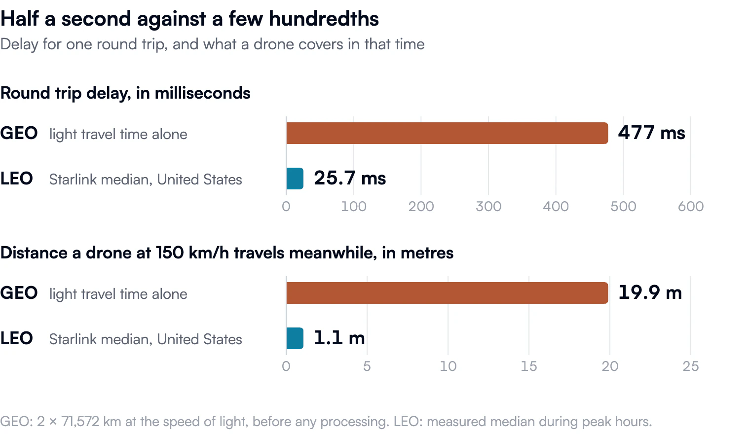
That equals about 239 milliseconds for one trip up to the satellite and back down (Dougherty, 2002). If a command must then travel back along a similar path, the total round trip approaches 477 milliseconds before any additional processing or routing delays. In practice, GEO connections often have round trip delays of roughly 500 to 600 milliseconds.
Half a second may not sound dramatic. But for a drone moving at speed, it is enough for the situation on screen and the situation on the ground to diverge.
The alternative in low orbit
Low Earth orbit, or LEO, generally refers to altitudes below about 2,000 kilometres. Satellites there are much closer to Earth, so signals have a far shorter distance to travel.
Modern LEO broadband networks can achieve round trip delays in the tens of milliseconds. Starlink, for example, has reported a median latency of 25.7 milliseconds in the United States and has described 20 milliseconds as an engineering target (Starlink, n.d., 2024). Assessments with a defence focus commonly place LEO satellite links in a range of roughly 40 to 80 milliseconds, depending on the network design and route.
For a drone operator, this can be the difference between controlling an aircraft with a delayed video feed and operating much closer to real time.
The price is complexity. A GEO satellite can cover a huge area because it is far away. A LEO satellite is closer, so it covers a smaller area at any given moment and moves rapidly across the sky.
A simple comparison helps: hold a flashlight close to a wall and it lights a small, bright area. Move it farther away and the light covers more of the wall, but becomes more spread out. GEO satellites are like the distant flashlight: broad coverage, but longer signal paths. LEO satellites are like the nearby flashlight: smaller coverage at any moment, but much faster communication.
To provide continuous service, LEO operators therefore need many satellites, frequent handovers between them, ground stations and sophisticated network management. Some systems also use laser links between satellites, allowing data to travel through space rather than always returning to a ground station.
Why this matters for drones
For drone warfare, lower latency matters in several ways.
First, it improves remote piloting. A drone beyond the visual range of its operator may rely on satellite communications for control and video. With GEO, the operator may be reacting to an image that is already half a second old. With LEO, the delay can fall to a fraction of that, making precise movement, tracking and evasion more feasible.
Second, it affects targeting and intelligence. Modern drones generate large amounts of video and sensor data. If that information reaches commanders slowly, the picture used to make decisions may no longer match reality. Faster links can help units share imagery, track movement and coordinate more quickly.
Third, it influences command and control. Military operations depend on more than one drone and one operator. Aircraft, ground units, commanders and intelligence analysts must exchange information. Latency affects the speed of that wider network, not merely the link between a pilot and a single aircraft.
None of this means that low latency automatically creates an effective military capability. A connection can be fast but insecure, vulnerable to jamming, dependent on a single provider, or unavailable in a particular region. Reliability, encryption, coverage and resilience remain just as important as speed.
Autonomy does not remove the problem
Some argue that autonomous drones make satellite latency less important. If a drone can identify objects, follow a route or avoid obstacles onboard, it may not need constant instructions from a human operator.
That is partly true. Greater onboard autonomy can reduce dependence on a continuous control link. But it does not eliminate communications. Operators may still need to receive imagery, change mission parameters, coordinate with other units or retain human oversight over the use of force.
In practice, autonomy and communications are complementary. A more autonomous drone may tolerate temporary communication loss better than a remotely piloted one. Yet for military coordination, intelligence sharing and accountability, fast and secure data links remain essential.
From military satellites to commercial networks
Military communications have traditionally relied on dedicated military satellites, many of them in GEO. These systems provide broad coverage and support forces operating far from terrestrial infrastructure.
The rise of large commercial LEO constellations changes that picture. Instead of relying on a small number of expensive satellites at high altitude, armed forces can potentially use networks made up of hundreds or thousands of spacecraft in lower orbits. These systems can offer lower delay, greater capacity and a more distributed architecture.
The war in Ukraine has shown the operational value of commercial satellite connectivity when conventional communications infrastructure is damaged or unavailable. Commercial networks can support communications, data exchange and coordination. But they are not military systems in the traditional sense: their availability depends on technical capacity, commercial decisions, national regulation and the policies of private companies.
This creates a new strategic dependence. A state may benefit from commercial space infrastructure, but it may also become reliant on a company that can restrict service, change its terms of use, or become a target itself. In space, military capability is increasingly intertwined with private infrastructure.
Infrastructure for civilian and military use
Satellite networks inherently serve both civilian and military purposes. The same infrastructure can support civilian internet access, disaster response, navigation, weather monitoring and military communications.
This overlap makes the boundary between civilian and military space infrastructure less clear. A commercial broadband constellation may serve ordinary customers while also supporting military users. That can increase flexibility and resilience, but it also raises difficult questions: Who controls the network? Who can access it during a conflict? What happens if a private provider withdraws service?
The answer is not simply to choose between GEO and LEO. GEO remains valuable for persistent communications across wide areas. LEO offers lower latency and a more distributed architecture. A resilient military communication system may need both, alongside terrestrial radio, fibre networks and autonomous capabilities.
Conclusion
Satellite altitude has direct military consequences. GEO satellites provide broad and persistent coverage, but their distance creates substantial delays. LEO constellations reduce those delays dramatically, making them increasingly relevant for drone operations, intelligence sharing and command and control.
For drone warfare, milliseconds are not a technical detail. They shape how quickly an operator sees, decides and acts. As military operations become more connected and depend more heavily on data, the design of satellite networks has become a central strategic question, and so has the growing role of commercial providers within them.
- Dougherty, S. A. (2002). An examination of latency and degradation issues in unmanned combat aerial vehicle environments [Master’s thesis, Air Force Institute of Technology, AFIT/GOR/ENS/02-05]. https://apps.dtic.mil/sti/tr/pdf/ADA401808.pdf
- Riebeek, H. (2009, September 4). Catalog of Earth satellite orbits. NASA Earth Observatory. https://science.nasa.gov/earth/earth-observatory/catalog-of-earth-satellite-orbits/
- Starlink. (2024). Improving Starlink’s latency. https://www.starlink.com/public-files/StarlinkLatency.pdf
- Starlink. (n.d.). Network update. https://starlink.com/updates/network-update